Where is MH370?

Where is MH370? 

Richard Godfrey
14th February 2016
 
Introduction 

The search for MH370 continues without success. In a previous post dated 5th January 2016, I asked the question “Is the search for MH370 being conducted in the right area?” Henrik Rydberg of the Independent Group (IG) ran a large Monte Carlo simulation to show that the feasible latitude distribution at 00:11 UTC (i.e. at the 6th Arc) ranged from 29S to 40S. There are, of course, many conceivable flight paths depending on assumed values for the location of the Final Major Turn (FMT) southwards, the speed mode, the autopilot mode, the fuel performance, the altitude, step climbs, lateral offsets, winds, magnetic declination, and whether there was a pilot at the controls or not.

Background 

Numerous analyses have been performed, based on differing assumptions, to try and determine (so far as is possible given the limited data, and its inherent imprecision) the final resting place of MH370. The key assumptions that must be made derive from the answers adopted when asking the following questions:

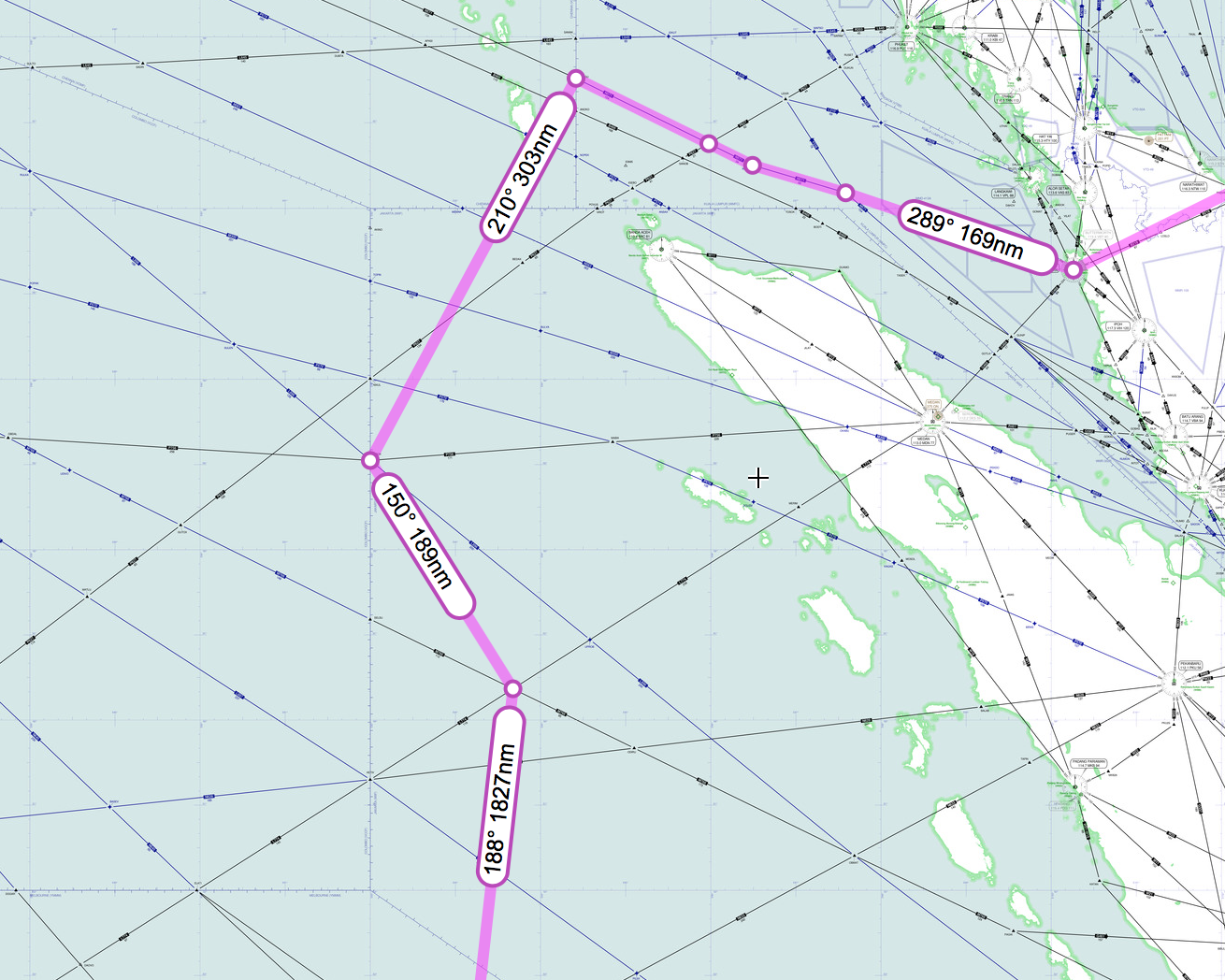
  • When and where did the FMT take place?
  • Was time spent “loitering” before (or soon after) heading southwards into the Indian Ocean?
  • Which autopilot mode was engaged (if any)?
  • What was the speed of MH370 heading southward?
  • What was the speed mode (ECON 52, constant Mach, LRC, etc.)?
The aircraft speed 

The last speed transmitted from MH370 via ACARS at 17:06:43 was Mach 0.821, which renders a True Air Speed (TAS) of 484 knots and a Ground Speed (GS) of 472 knots. The last ADS-B transmission from MH370 at 17:20:35 was a GS of 471 knots, in accord with the preceding.

Victor Iannello in his analysis dated 18th August 2015 of the available radar data  showed that those data are consistent with a speed of Mach 0.84 and Flight Level 340 as MH370 crossed back over the Malaysian Peninsula and then north west over the Malacca Strait.

The maximum cruise speed of the Boeing 777-200ER with Rolls Royce engines is Mach 0.84. The minimum speed with flaps up at an aircraft weight of 200,000 kg and an altitude of 34,000 feet is Mach 0.73, which gives a TAS of 433 knots at an air temperature of -41.0°C (or Indicated Air Speed [IAS] of 250 knots). That minimum speed can be reduced if the altitude is also reduced; for example at 20,000 feet the minimum speed is Mach 0.47, which gives a TAS of 296 knots at an air temperature of -11.9°C (or IAS of 215 knots).

Method 

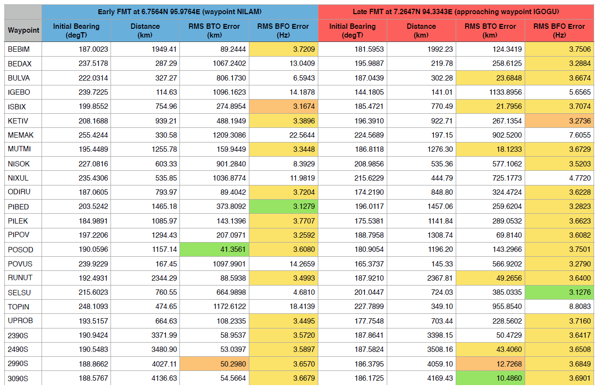
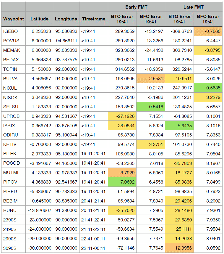
Using my MH370 Flight Path Model I calculated the best fit flight path to the BTO satellite data between 19:41 UTC and 00:11 UTC. I examined all speeds between constant Mach 0.68 and constant Mach 0.84, together with both an early and a late FMT, as well as all autopilot roll modes. I kept the altitude constant at 34,000 feet until 00:11 UTC. (A recent discussion of some of these aspects is available here.)

These modelled flight paths resulted in end points at 00:19 UTC (i.e. on the 7th Arc) lying between 30.5S and 39.3S, considering all speeds, FMT variations and autopilot roll modes.

Results 

The results of these calculations for the Late FMT assumption along with a True Track autopilot roll mode are shown in Table 1 below:

OuEstMH370_table_1
 Table 1: Outcomes of flight model runs from a Late FMT using  a True Track mode and a constant speed of between Mach 0.68 to 0.84. (GS=Ground Speed; FMT=Final Major Turn; RMS=Root-Mean-Square; BTO=Burst Timing Offset; BFO=Burst Frequency Offset; ROC=Rate of Climb in units of feet per minute.)

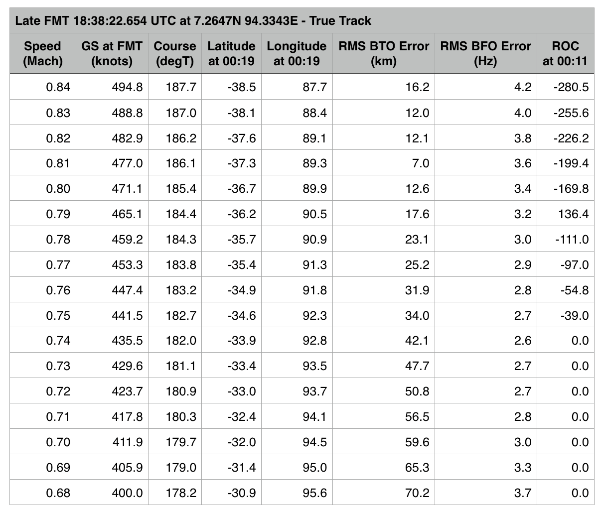
The best-fit flight path (as shown in Table 1 above) was in a True Track roll mode from a Late FMT at a constant Mach 0.81 on a course of 186.1°T, resulting in a RMS BTO error of 7.0 km and an end point at 00:19 UTC of 37.3S 89.3E.

The next-best fit flight path was in a Magnetic Heading roll mode from an Early FMT at a constant Mach 0.84 on a course of 195.3°T giving a RMS BTO error of 10.6 km and an end point at 00:19 UTC of 39.1S 87.1E, as in Table 2 below.

OuEstMH370_table_2
Table 2: Outcomes of flight model runs from an Early FMT using  a Magnetic Heading mode and constant speeds of 

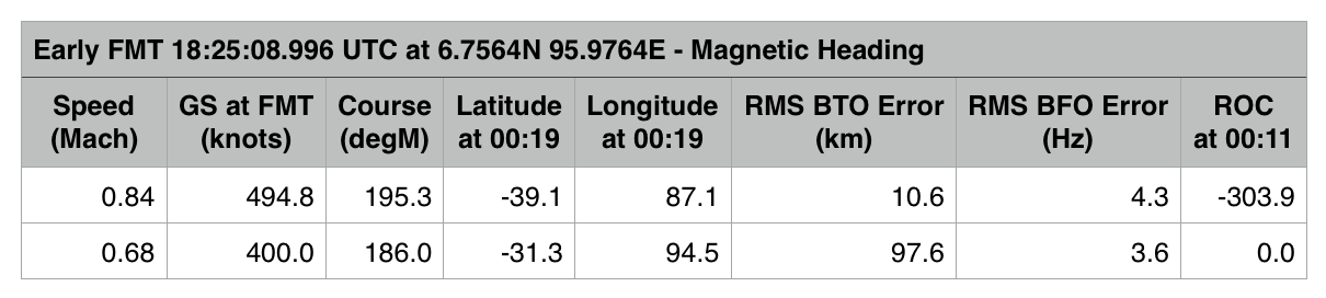
Mach 0.68 and 0.84 (only). 

Discussion 

In Brian Anderson’s post dated 20th March 2015, he estimated that the GS of MH370 at the time of the closest approach to the satellite of (i.e. the tangent position, which occurred at 19:52 UTC) was 494 knots and the TAS was 484 knots. Brian used a completely independent method to arrive at that conclusion.

Using my model, the best-fit MH370 flight path identified above, with a True Track roll mode from a late FMT at a constant Mach 0.81 on a course of 186.1°T, is shown in more detail below in Table 3.

At 19:41 the TAS is 480 knots and the GS is 486 knots. The TAS is within 1 per cent of Brian’s result but depends on the air temperature of -41.2°C that was assumed in my model, and the GS is within 2 per cent of Brian’s result but depends on the wind speed of 27.1 knots from a direction 84.7°T that was assumed.

OuEstMH370_table_3
Table 3: Detailed output information from the best-fit solution identified above (i.e. Mach 0.81 in Table 1). 

Conclusion 

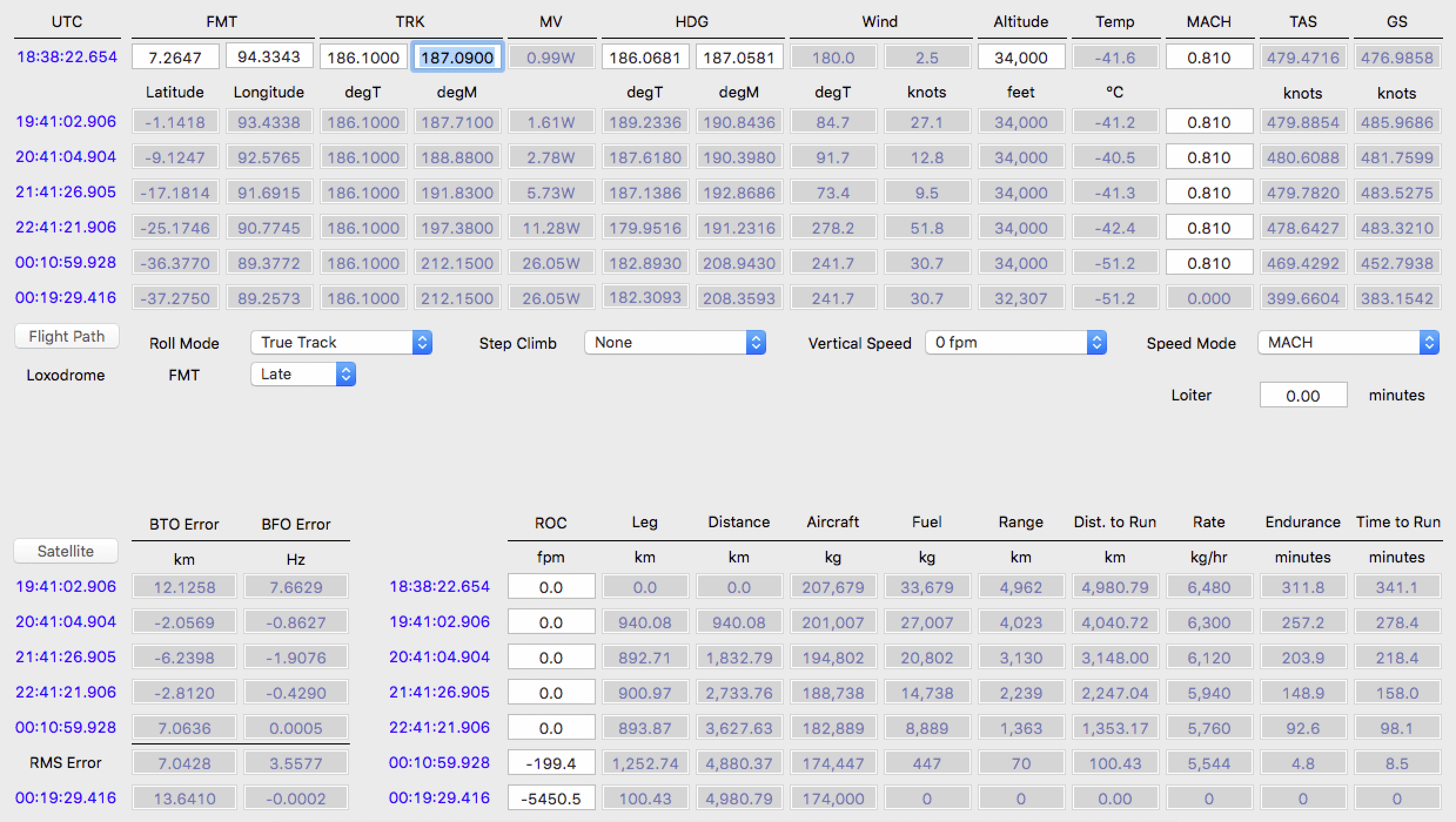
I have tried to follow the principle of making the fewest assumptions possible in arriving at the result of 37.3S 89.3E. These assumptions are:

1. The Inmarsat satellite data are valid.
2. A late FMT, which generally gives a much better match to the satellite data.
3. There was no change in the speed of Mach 0.81 between the FMT and 00:11 UTC.
4. There was no change in altitude from 34,000 feet until 00:11.
5. There was no time spent loitering before or after the FMT.

An outcome of this model and therefore this set of assumptions is that MH370 entered the water soon after 00:19 UTC and within 15 nautical miles of the 7th Arc. As can be seen in Table 3, this result is consistent with the fuel availability/expected exhaustion.


ATSB Search Questions
A valid question to ask is this: If the final resting place of MH370 is near 37S and the 7th Arc, and this area has been searched by the ATSB, why has MH370 not been found?

It could be that the assumptions stated above are incorrect. For example, the speed changed or the altitude changed.

However, the question remains whether the sea bed debris has been missed:

  • Are the search path swathes, with a width of 1.8 km, too wide for the side-scan sonar currently employed (900 m either side of the tow fish)?
  • Is the sea bed extremely rocky and undulating, requiring narrower search path swathes or multiple overlapping swathes in order to ‘see’ into the sea bed troughs?
At this stage, we have no answers. As I have pointed out previously (and also above, in recognizing that one or more of my underlying assumptions might be wrong), it is conceivable that a slower route that ends up at a lower latitude (e.g. 29S to 35S) yet still close to the 7th Arc might actually have been flown, but the best estimate of the final location of MH370 remains close to 37S until such time as we have a high level of confidence that the wreckage is not within the ATSB priority search zone (i.e. the entire zone has been searched, and the wreckage has assuredly not been missed through the difficulties and vagaries of the sea-bottom search).

Comparison of MH370 Flight Paths Based on Waypoints

Comparison of MH370 Flight Paths
Based on Waypoints

Richard Godfrey
1st February 2016


Introduction
Many different flight models have been developed to try and fit the Inmarsat satellite data to plausible flight paths that may have been flown by MH370 under an assumption of autopilot control.

Here are a couple of typical examples:

  1. An assumed true track (TT) mode usually results in the choice of a late final major turn (FMT), fitting a course of around 186.2°T (i.e. azimuth 186.2 degrees from true north); this results in a RMS BTO error of 9.2 km and a RMS BFO error of 3.7 Hz. (RMS = root mean square; BTO = burst timing offset; BFO = burst frequency offset).
  1. A magnetic heading (MH) mode usually results in the choice of an early FMT, fitting a course of around 193.8°M (i.e. degrees from magnetic north), which results in a RMS BTO error of 18.3 km and a RMS BFO error of 3.9 Hz.

There are, of course, many other conceivable flight paths depending on assumed values for the location of the FMT, the speed mode, the altitude, step climbs, lateral offsets, winds, magnetic declination, etc.


Background
There are two problems in particular with these typical flight model examples:

  1. The BFO error obtained at 19:41 UTC is much higher than at other times later in the flight: around 8 Hz compared with a typical BFO error of between 1 Hz and 4 Hz.
  1. The BFO data for the first attempted phone call shows a fairly steady path for 61 seconds (between 18:39:55 and 18:40:56 UTC) near either 161°T or 200°T (i.e. at azimuths close to equal angles each side of due south).

In order to see if these two problems could be resolved, I have examined alternative flight paths using a single waypoint entered into the Flight Management System (FMS) as opposed to a course selected using the heading bug; Mike Exner has argued that, if waypoint navigation were used after the FMT, then it is more likely that a single waypoint was entered.

Method
First, I entered each possible single waypoint from both an ‘Early’ and a ‘Late’ FMT (at times and locations shown in Table 1 below) into my flight model. I kept the altitude constant at 34,000 feet and speed constant at Mach 0.817 in all cases.

Next, I determined the RMS BTO and BFO errors in each case from 19:41 to 00:11 UTC (Table 1 below); I also noted the BTO and BFO errors at 19:41 UTC (Table 2 below).

Results
The results are given in the tables below. Green is used to highlight the best result, orange for the second best, and yellow for BTO errors below 50 km or BFO errors below 4 Hz.

Waypoint Table 1

Table 1: Derived RMS BTO and BFO errors for assumed paths to the waypoints as indicated in the far-left column for Early and Late FMTs at the locations shown. 

Waypoint Table 2

Table 2: BTO and BFO errors at 19:41 UTC for paths to waypoints as shown from both Early and Late FMTs as defined in Table 1. 


Discussion

  • The BTO error is clearly a better differentiator of the results than the BFO error.
  • The result with the smallest BTO error is not the same as the result with the smallest BFO error (the plot of BTO error against BFO error gives a smooth curve for both early and late FMTs).
  • It is easier to find results with a small BTO error with a Late FMT.
  • The result with the smallest RMS BTO error was the waypoint 3090S with a Late FMT (as Don Thompson has previously suggested).
  • The result that gave the smallest BTO error at 19:41 UTC was the waypoint ISBIX with a Late FMT.
  • The smallest BFO error at 19:41 UTC was the waypoint SELSU for an Early FMT (course 215.6°T) and the waypoint NIXUL for a Late FMT (also course 215.6°T).
  • Because these smallest BFO errors at 19:41 UTC result from a course of around 215°T and this was also not far off the possible path at 18:39:55 to 18:40:56 UTC (as mentioned above), further investigations were undertaken, as below.


Further Investigations
Using pairs of waypoints, the best result obtained was for ISBIX and 3090S; but this still did not solve the BFO problems at the time of the first phone call (near 18:40) or at 19:41 UTC.

However, using triplets of waypoints, the trio NISOK, ISBIX and 3090S led to a solution to both problems:

  1. The path obtained at 18:39:55 to 18:40:56 UTC was 208.9°T, which gives a BFO error of -2.6 Hz and a constant course during the timeframe of the first call.
  1. The BFO error obtained at 19:41 UTC is just 0.5 Hz.
  1. The overall RMS BFO error is 1.7 Hz.

NISOK is a waypoint between waypoint SELSU and waypoint NIXUL, and on the same longitude (see Table 2).

The resultant flight path is shown below. It could be argued that such a path might be that followed by someone wanting to avoid Indonesia to the extent possible, whilst confusing any observer as to the ultimate intention*.

Waypoint Analysis Flight Path


It is also noted that this path fits the location and directions of the suggested sightings by Kate Tee, although the timing is out by 30 minutes from her evaluation of the time in question (which is acknowledged to be a possibility).


*Note added by Duncan Steel: A contrary argument would be that the ultimate disappearance of MH370, and in particular its apparent non-detection by Indonesian radars, is conditional upon such a path having been taken. That is, such a path having been taken either accidentally or automatically (i.e. no pilot intent) results in the aircraft’s disappearance, and if such a path had not been taken then we would be more likely to know where it went. The path that Richard has suggested, based on detailed analysis, might be considered to have a low probability a priori; but a posteriori it might be that the disappearance of the aircraft is contingent upon that path (or one very much like it) having been followed, whether by chance or by intent.