The long hunt for a diversion airport
Richard Godfrey
18th October 2016
MH370 passed waypoint IGARI at 17:20:31 UTC, and its transponder apparently stopped sending within one minute of passing that waypoint. Similarly, the VHF radios and SATCOM stopped transmitting at around the same time (source: Malaysian Factual Information, ADS-B, ATSB, DSTG).
Where did MH370 go from there and why?
Here is an attempt to answer that question.
Statements below such as “MH370 passed close to WMKC” should be understood to mean “under this working hypothesis, MH370 is assumed to have passed close to WMKC ” (and similarly elsewhere).
Diversion 1
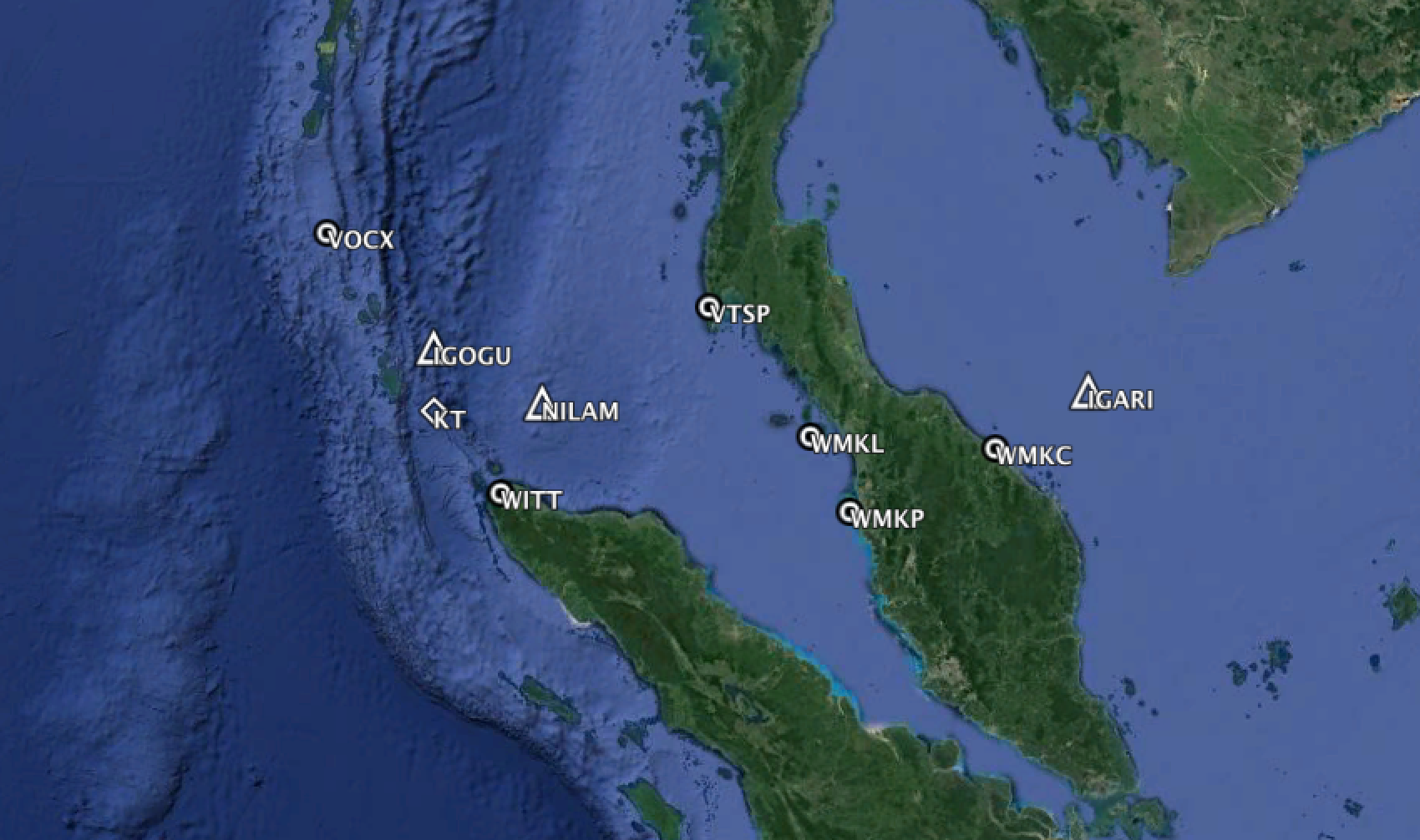
At this point, just past waypoint IGARI, the nearest diversion airport with an adequate runway, was at Kota Bharu (WMKC), at a distance of 89.6 NM (11.2 minutes flying time) on a bearing of 241.5°T.
MH370 initiated a turn back at 17:21:53 UTC toward WMKC.
MH370 passed close to WMKC at 17:36:33 UTC, but it was decided not to attempt a landing.
WMKC only operates from 06:00 to 23:30 local time and therefore had been closed for 2 hours.
A Boeing 777-200ER with Trent engines has a maximum landing weight of 213,180 kg. The weight of MH370 at 17:36:33 UTC is estimated at 214,736 kg. This is over the maximum landing weight, but that would not have prevented an attempted landing in an extreme situation.
Diversion 2
At WMKC, the nearest next diversion airport was at Penang (WMKP), at a distance of 137 NM (15.5 minutes flying time) on a bearing of 242.8°T.
MH370 passed close to WMKP at 17:51:43 UTC, but it was also decided not to attempt a landing.
WMKP operates 24 hours but with restrictions. There are currently no scheduled arrivals or departures between 00:40 and 06:25 local time. MH370 passed by at around 01:51 local time.
The weight of MH370 at WMKP is estimated at 213,085 kg and marginally within the allowed maximum landing weight.
Diversion 3
At WMKP, the nearest diversion airport was at Langkawi (WMKL), at a distance of 72.4 NM (8.3 minutes flying time) on a bearing of 330.7°T.
WMKL only operates from 07:00 to 23:00 local time. A diversion to WMKL was not attempted.
MH370 proceeded across the Malacca Straits toward waypoint VAMPI, where fuel could be dumped or at least used up (if the fuel dumping pump had failed). This would reduce the risk incurred in any emergency landing.
Diversion 4
At waypoint VAMPI in the Malacca Strait, the nearest diversion airport was at Phuket (VTSP), at a distance of 126.1 NM (14.7 minutes flying time) on a bearing of 20.3°T.
VTSP operates 24 hours and is quite a busy airport serving the tourist area in Southern Thailand. A diversion to VTSP was not attempted.
MH370 proceeded on Flight Route N571 up the Malacca Strait.
Diversion 5
At waypoint NILAM, the nearest diversion airport was at Banda Aceh (WITT), at a distance of 82.6 NM (10.1 minutes flying time) on a bearing of 205.1°T.
WITT only operates from 07:00 to 18:00 local time. A diversion to WITT was not attempted.
MH370 proceeded on Flight Route N571 toward the Andaman Islands.
Diversion 6
At waypoint IGOGU, the nearest diversion airport was at Car Nicobar (VOCX), at a distance of 118.4 NM (14.4 minutes flying time) on a bearing of 307.1°T.
VOCX is operated by the Indian Air Force and is seldom used for commercial traffic. It does not operate 24 hours. They even let cattle stray onto the runway and there is a cautionary note in the pilot’s guide for VOCX to this effect. A landing at VOCX was not attempted.
Diversion 7
At this point you run out of diversion airports that are close by.
The next diversion airport would be Colombo Airport (VCBI) but that is 777 NM and 1.5 hours away.
Colombo Airport operates 24 hours and is quite busy, but if you have a problem with the transponders, VHF radios and possibly even the aircraft lights (navigation and landing lights might have failed due to an electrical problem), you would prefer a quiet airport.
It is easier to land in the daylight than at night (especially without functioning landing lights), so going further west is not the answer to being able to land in daylight, you should rather head east and south.
Sunrise on 8th March 2014 was at 07:22 local time in Kuala Lumpur, but at 05:06 local time in the Cocos Islands.
Cocos Island Airport (YPCC) has an adequate runway and is a quiet airport with little traffic, and MH370 could make it there just before sunrise.
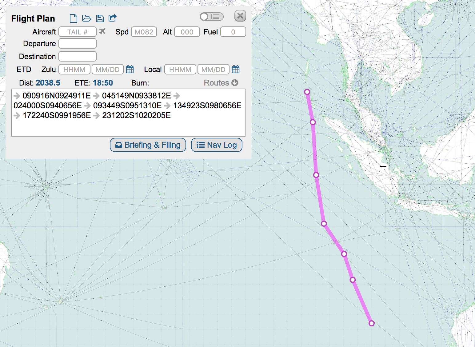
Hypothesis: MH370 turned south east on a bearing of 169.4°T for Cocos Island Airport.
Obviously, MH370 did not land at Cocos Island Airport either and appears to head at first for Learmonth (at the NW tip of Australia) and later for Perth instead (neither of were reachable with the remaining fuel).
Airport Surface Winds
In all cases, the surface winds at each possible diversion airport were light and would not have prevented an attempted landing (see table below).
BTO and BFO data
The BTO and BFO data show essentially a perfect fit for a flight path from VOCX to YPCC as above.
At each point the BTO error and the BFO error is zero (although I still believe the approach used in the McMurdo paper is better, where BTO and BFO errors are constrained only to certain limits).
In contrast to the McMurdo flight route, this option allows changes after VOCX in both heading and Mach speed.
The McMurdo flight route, with a constant Great Circle path and constant Mach, does not require an active pilot after VOCX, whereas this hypothesis requires an active pilot until the end.
Kate Tee
The flight path from VOCX to YPCC passes close to the possible sighting made by Kate Tee.
If there was no loiter at VOCX, the timing of the Kate Tee sighting also fits.
I estimate MH370 was at VOCX at 19:02:33 UTC and would take 22 minutes 36 seconds to reach the area around the Kate Tee sighting at 6.63N 94.44E.
This would give an arrival time in the area where Kate Tee made her sighting at about 19:25:09 UTC.
From the GPS log of Kate Tee’s boat, the time of the MH370 sighting was placed at around 19:25:20 UTC.
Drift Analysis
The MH370 end point following the flight path from VOCX, past YPCC until fuel exhaustion is located near 23°S 102°E.
Although there have been several drift analyses reported with a range of results, their common factor is that the floating debris started from a point much further north than the current search area.
Table, Map and Flight Route
The table below indicates the relevant data, the key points mentioned and the subsequent flight route. The map following it indicates the locations of the points mentioned above. After that is a map showing the flight route southwards that results from the modelling described above.

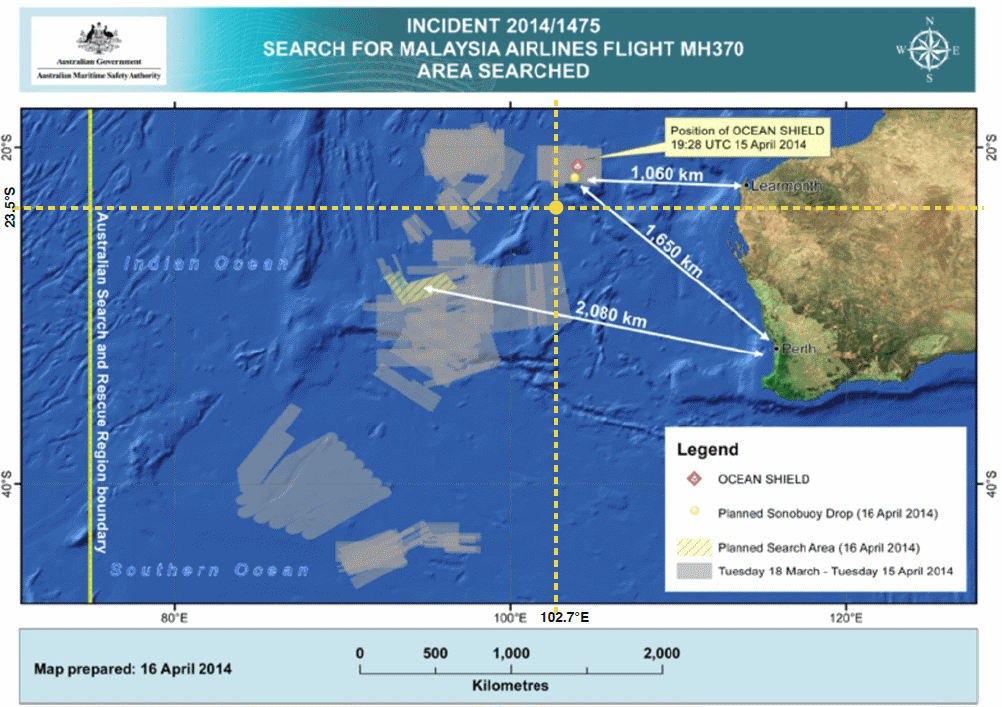
The map below was published by AMSA on 16th April 2014 and shows the cumulative aerial search area for MH370. To that map has been added the yellow dashed lines, indicating the crash location suggested here. As can be seen, there is a large gap around the hypothesised MH370 end point of 23.5°S 102.7°E on the 7th Arc.
Global Drifter Program Buoy 101703
The Global Drifter Program maintains a global array of 1,250 buoys covering all the oceans of the world. These buoys or drifters have a drogue or sea anchor, which ensures that the buoy flows with the currents.
Data are sent from the buoy via satellite every 6 hours, giving position, speed, sea temperature, etc.
Buoy 101703 was launched in the Indian Ocean on 12th July 2013 at 29.011°S 105.076°E, off the coast of Australia (and marked with a bright green dot on the map below). The path of the drifter buoy is marked with dots (white means slowest speed, red means fastest speed).
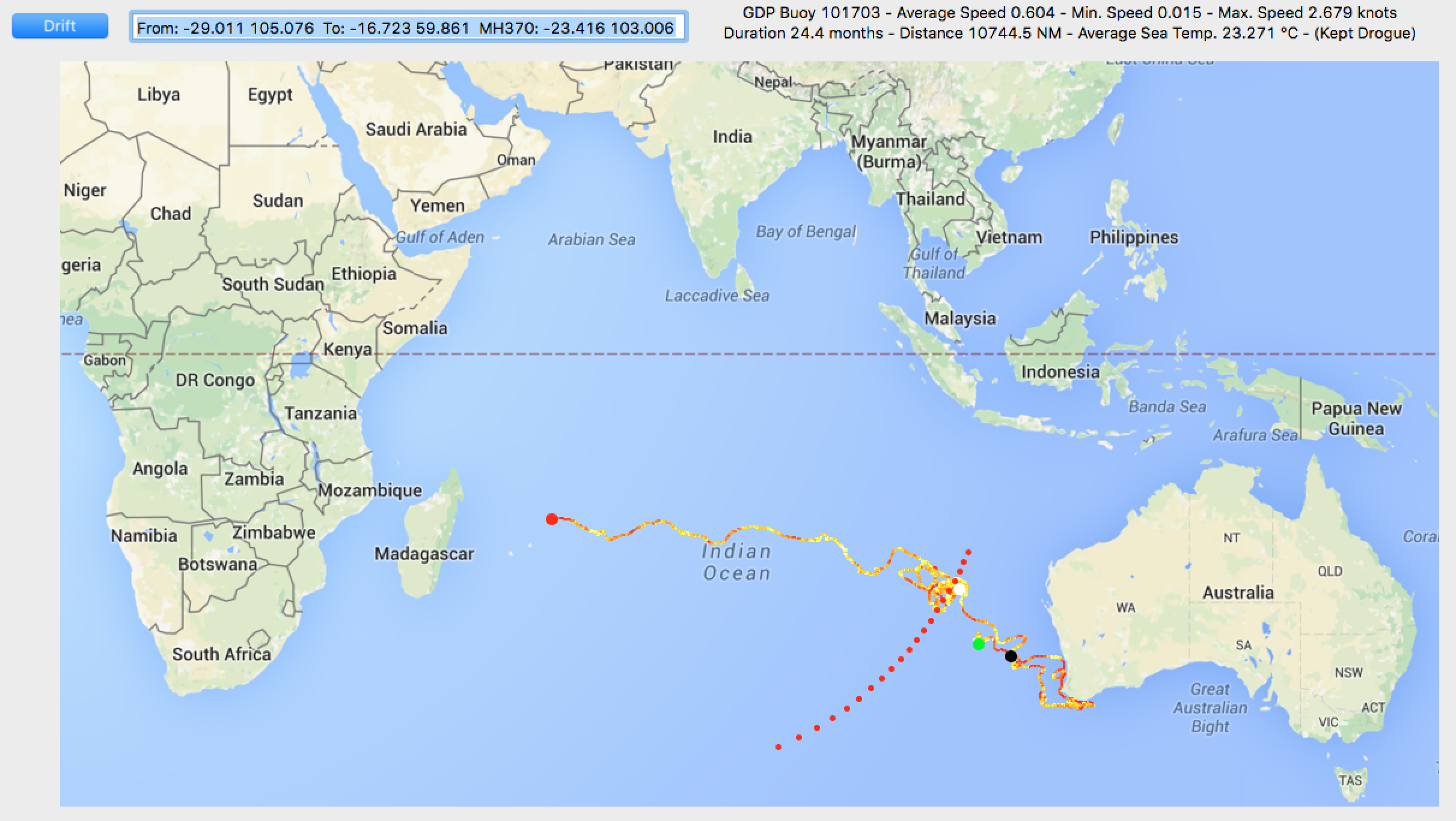
This buoy is of particular interest because it passed the 7th Arc close to the hypothesised MH370 end point of 23.5°S 102.7°E on 8th March 2014.
On 8th March 2014 at 00:00 UTC, buoy 101703 was at 23.416°S 103.006°E (marked with a large white dot on the map above).
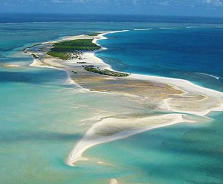
The buoy ended on 23rd July 2015 at 16.730°S 59.830°E in the Cargadas Carajas Shoals (pictured below) 232 NM north east of Mauritius (marked with a large red dot on the map above).
Other buoys in the area of the 7th Arc on 8th March 2014 show a similar pattern.
The average speed of buoy 101703 was 0.604 knots and the maximum speed reached was 2.679 knots (marked with a large black dot on the map above).
The overall distance travelled by this buoy is similar to that covered by the MH370 flaperon, which drifted in the same time frame to arrive in Réunion on or before 29th July 2015, 6 days after buoy 101703 arrived at its end point.
It is evident that the buoy 101703 spent a lot of time around the 7th Arc from 8th March 2014 onwards. Other buoys made a more direct route across the Indian Ocean.
In fact it was not until 22nd November 2014 that this buoy left the area of the 7th Arc to begin its journey to the Cargadas Carajas Shoals.
If MH370 ended at 23.5°S on the 7th Arc, then it is possible that floating debris stayed in that area for several months.
Global Drifter Program Buoy 101703 from the 7th Arc
When the buoy finally started its journey from the 7th Arc, it took 8 months to reach its destination 3,390 NM away, at an average speed of 0.579 knots and a maximum speed of 1.55 knots near the end (see map below).
The buoy kept its drogue for the whole journey and therefore provides reliable drift data.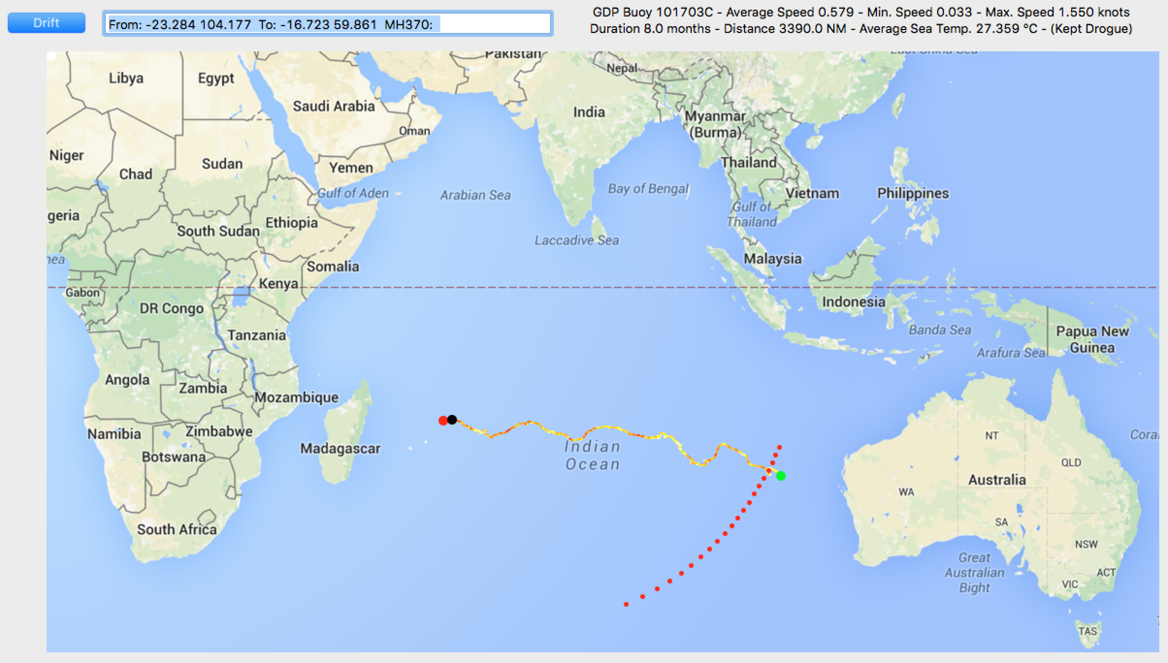
Goose Barnacles
The flaperon found in Réunion carried a significant population of goose barnacles.
The average sea temperature for the journey of the buoy 101703 across the Indian Ocean was 27.359°C.
Goose barnacles (Lepas anatifera) are most abundant in tropical and subtropical waters where sea temperatures exceed 18-20 ºC. (Castro, et al., 1999; Nobanis, 2008; Patel, 1959).
Approximately 120 days after settlement these barnacles develop reproductive organs at temperatures between 10.2 to 18.4 ºC, but the reproductive development takes 30 days, if the surface temperature of the water is around 25 ºC. (Anderson, 1994; Cowles, 2005; “Goose barnacle (Lepas anatifera)”, 2010).
The warmer waters in the journey from 23.5°S would favour the colonisation and reproduction of goose barnacles, therefore indicating a likelihood of the flaperon spending more time at such latitudes.
Global Drifter Program Buoy 101665
As mentioned above, other buoys in the area of the 7th Arc on 8th March 2014 show a similar pattern.
For example, Buoy 101655 was launched in the Indian Ocean on 13th July 2013 at 27.360°S 104.753°E off the coast of Australia (marked with a green dot on the map below).
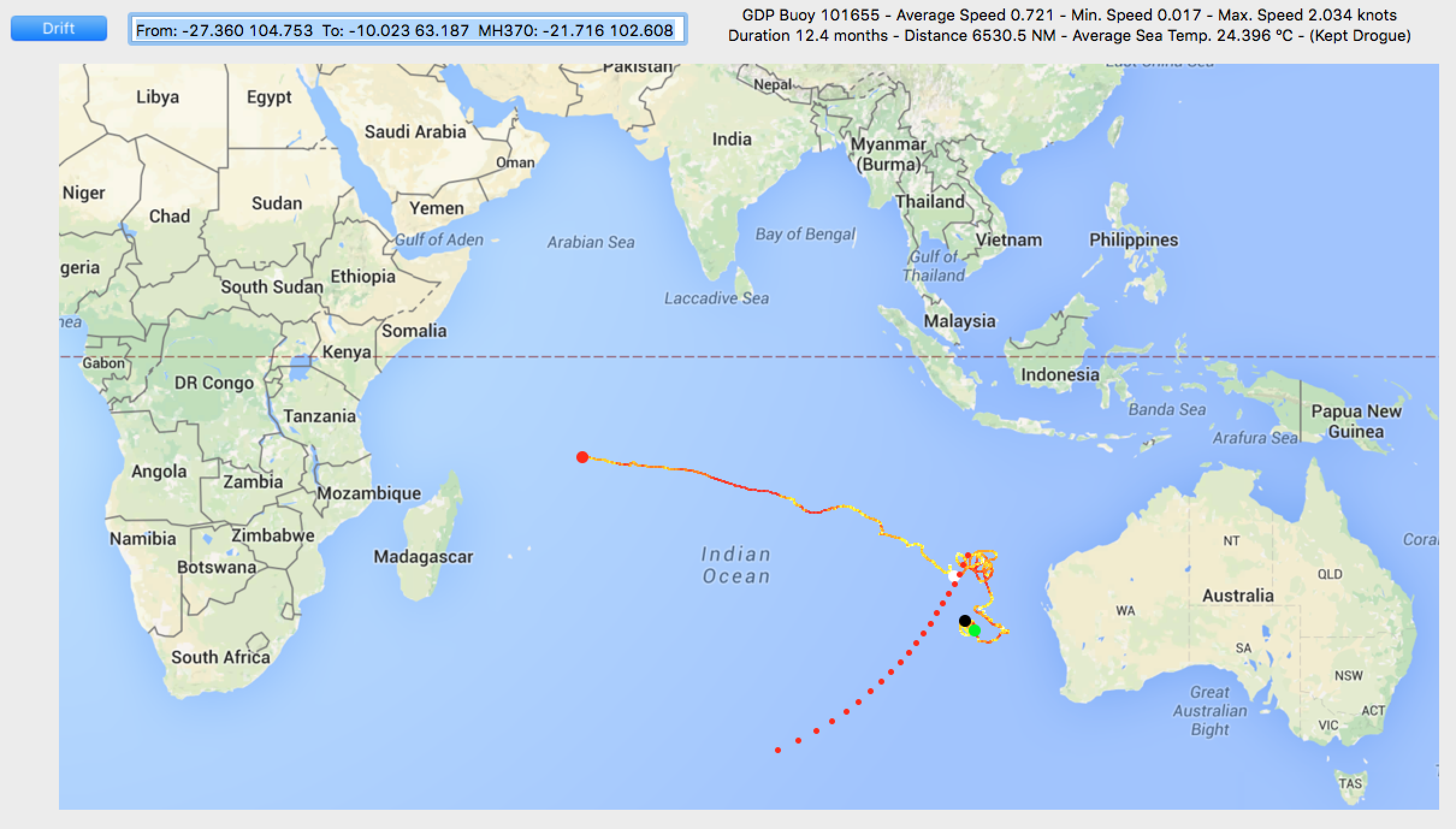
This buoy passed near the 7th Arc at 21.716°S 102.608°E on 8th March 2014 (marked with a large white dot on the map above).
The buoy ended, after a 4.6 month journey from the 7th Arc, on 26th July 2014 at 10.023°S 63.187°E in the Mascarene Plateau between Mauritius and the Seychelles (marked with a large red dot on the map above).