MH370 Flight Path Model version 15.1
by Richard Godfrey
2015 July 20th
Prefatory remarks by Duncan Steel:
Over recent months, despite apparent silence, the Independent Group (IG) has continued to explore and debate possible interpretations of the data available with regard to the flight and loss of MH370. It is only occasionally that some understanding develops that is deemed worthy of the investment of time needed to prepare something for posting/publication here.
The item that follows is an update from Richard Godfrey of his MH370 Flight Path model, several versions of which have already appeared on this website. Each represents an improvement on that preceding, although it should be noted that the indicated end-point for MH370 has not shifted by much since June last year (2014).
People have often stated that MH370 cannot be in the southern Indian Ocean, because it has not been found by any of the searches (either airborne scans for floating debris immediately after the crash, or wreckage on the seabed through the ongoing deep-ocean sonar search). As Richard indicates at the end of the discussion below, only a limited fraction of the indicated search area on the seabed (that is, indicated by the outcomes of the IG path modelling) has yet been searched.
This does not mean that the IG (or anyone else) can be certain that MH370 crashed in the location derived in these calculations. Personally, I know never to be certain of anything, even the principle of the conservation of momentum: it is not clear to me that the principle would hold if inertial and gravitational mass were not strictly equivalent, but that might be due to my limited knowledge of the General Theory of Relativity.
My point, though, is that it is fundamentally unscientific to say one is certain of anything when it must be acknowledged that there are many facets of the flight of MH370 which are uncertain. For this reason Richard’s section headed Assumptions is vitally important. I might allow myself to be ‘certain’ of where MH370 ended up when the wreckage is found.
Due to the fact that it has not yet been found, various members of the IG have been considering alternatives. This is sensible, and commendable. As time goes by, if the wreckage of MH370 is not found in the indicated search region then it becomes more and more plausible that it is not there at all. How could this be? Well, one explanation might be that not all of the explicit Assumptions listed by Richard are valid. In addition it might be that there are implicit/unspoken assumptions that have been made, and have slipped by us.
Regardless, the sure-fire way in which one can avoid ever making a mistake is to do nothing at all. By making his model available to anyone and everyone, Richard lays himself open to criticism, as have the rest of us; but constructive criticism and/or the identification of mistakes are welcome.
MH370 Flight Path Model version 15.1
Introduction
Assumptions made in developing this flight path model
- MH370 was positioned at Kuala Lumpur Airport Gate C1 from at least a few minutes before 16:00 until push back at 16:28 UTC on 2014 March 07.
- The MH370 Inmarsat Communication Log BTO and BFO data are accurate.
- The MH370 ACARS position reports are accurate.
- The aircraft altitude remained constant except perhaps for a small climb near waypoint NILAM.
- There was a continuation of the apparent lateral offset of 10 nautical miles (NM) to the north of flight route N571 to a point approaching waypoint IGOGU on a track azimuth of 297 degT (degrees True; equivalent to 298 degrees magnetic), which is in accord with the BFO data values at 18:28; see Figure 1 below for this lateral offset.
- All turns are modelled as being performed at a bank angle of 15 degrees.
- The autopilot LRC Thrust Mode results in a reduction in True Air Speed (TAS) from Mach 0.834 down to 0.786, resulting in a ground speed of about 490 knots at 18:25 UTC reducing to 432 knots at 00:11 UTC (on 2014 March 08).
- After a Final Major Turn (FMT) towards the south at a point slightly to the east of IGOGU a constant track path was flown from 18:41:57 UTC onwards in the direction 185.641 deg T.
Method
I have used all the R-Channel and C-Channel BTO and BFO data values, performing a calibration against known ground data and ACARS position data.
I then used this constant track to calibrate C-Channel number 6 using only data from between 23:14 and 23:15 UTC (30 BFO values), which gave a best fit for a C-Channel 6 BFO Offset of 143.181 Hz with an RMS BFO Error of 1.5 Hz.
I then used this BFO Offset of 143.181 Hz for C-Channel 6 during the earlier part of the route flown by MH370, at around 18:39—18:40 UTC (49 BFO values); that is, I assumed that this BFO Offset calibration from later in the flight could also be applied to this earlier juncture, in order to obtain information on the direction of travel at that earlier time.
This rendered a constant track of approximately 144.8 degT over 15 km (8.2 NM) and for a duration of 61 seconds. This corresponds to a direction towards Banda Aceh Sultan Iskandar Muda International Airport (a path which was hypothesised by Victor Iannello in the middle of 2014: that is, a deviation by MH370 onto a path preparatory for a landing at that airport). The BFO values across this 61 seconds vary between 86 Hz and 90 Hz, representing indicated path azimuths between 137 degT and 147 degT.
Findings
The results obtained in this model fit a major turn and cancellation of the lateral offset approaching IGOGU, and a turn onto a track of 144.8 degT to line up with Banda Aceh Sultan Iskandar Muda International Airport Runway 17, which is 3000 metres in length, paved and lighted. The diagram below (Figure 1) indicates the overall path in this region as derived in this model V15.1.
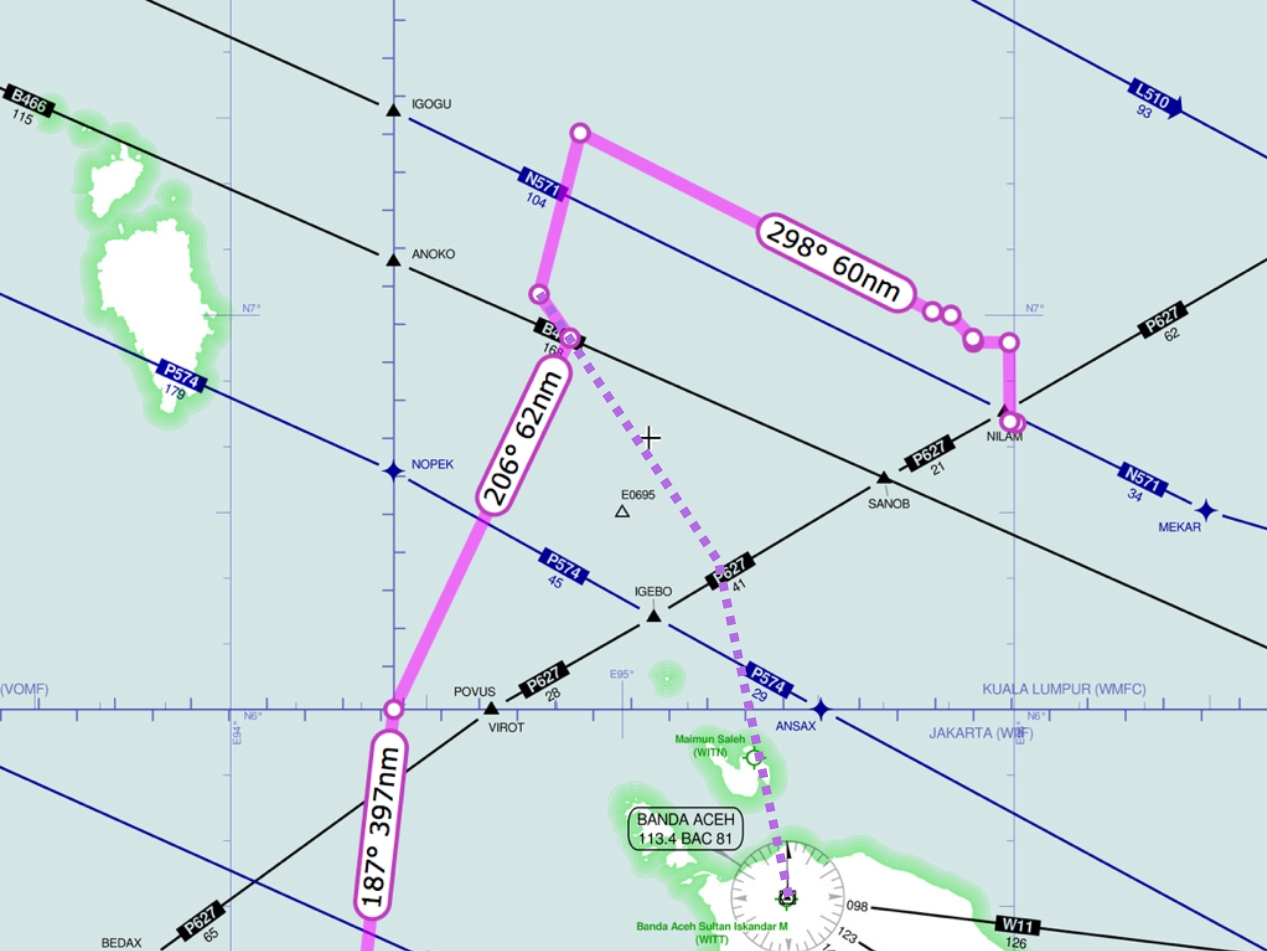
Figure 1: Path solution for MH370 derived in this Flight Path Model V15.1; all azimuths are shown in degrees magnetic (degM, rather than degrees True, degT). A PDF file containing this map is available here.
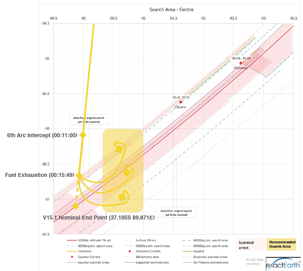
The approach towards Banda Aceh was apparently aborted and instead a track of 185.6 degT was followed until fuel exhaustion at around 00:15:49 (see Figure 1 above for the indicated path to the west of Sumatra). As throughout, no explanation is offered for the conscious choice or otherwise of any path derived here; all that is being presented are fits to the sparse available data, with explanations of how the fits were performed, so that others might be able to build on this work (or perhaps identify mistakes).
V15.1 end point and indicated search region