Dependence of the Orbital Debris Collision Hazard upon Inclination for Low-Earth Orbit Satellites
Duncan Steel
2015 April 28
Introduction
In my previous post concerning the orbital debris collision hazard for test satellites in low-Earth orbit (LEO) I used only two values of the inclination to the equator (30 and 98 degrees) as examples, that post being directed mainly towards elucidating how the collision probabilities vary with altitude. I wrote there that I would prepare another post that focusses upon the inclination-dependence: this is it.
The method and input orbital data for tracked objects used here are precisely the same as in that first post, and so I will not repeat what I presented there in that regard.
In Figure 1 below I show how the collision probability varies with the inclination of various test satellites (assumed spherical, cross-section one square metre) in circular orbits at differing altitudes in the LEO zone. The inclinations used go in ten degree steps from 0 to 180 degrees, except that three additional inclinations were inserted: 28.5 degrees (the geocentric latitude of Cape Canaveral), 45 degrees (near the latitude of the Baikonur launch site) and 98 degrees (the approximate inclination of satellites in sun-synchronous orbits in LEO).
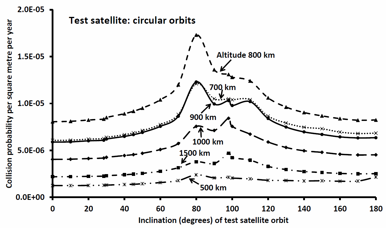
Figure 1: Variation of the collision probability against the publicly-available orbits of tracked objects in geocentric orbit as a function of inclination for circular test satellite orbits at altitudes of
500, 700, 800, 900, 1000 and 1500 km.
Discussion
The following salient points can be understood from Figure 1:
- Whilst all lines for any particular satellite altitude show peaks between 60 and 120 degrees, at higher inclinations (i.e. highly retrograde test orbits) the collision probabilities reduce. Given that the collision probability varies linearly with the relative velocity of potentially-colliding objects, and the fact that most of the tracked objects are in prograde orbits, this might not have been expected. The explanation for this feature (i.e. decreases in collision probability for highly retrograde orbits) is that if the orbital plane of the test satellite is close to the equator – whether prograde (i < 60 deg) or retrograde (i > 120 deg) – then that satellite spends much of each orbit at lower latitudes than the preponderance of tracked objects in near-polar orbits. This results in the overall collision probability being reduced.
- The lines for test satellite altitudes 700, 800 and 900 km show broad maxima centred on inclination 80 degrees, and may be understood as being a result of the collision probability varying with the relative velocity of potentially-colliding objects: a satellite at such an inclination (say 80-100 degrees) has an elevated probability of colliding head-on with a piece of tracked debris (or indeed a functioning payload) that has a similar inclination but is travelling in the opposite direction. In addition, the collision between Cosmos 2251 (inclination 74 degrees) and Iridium 33 (inclination 86 degrees) at an altitude of about 789 km resulted in almost 2,000 items of tracked debris (and many smaller).
- The highest collision probabilities are at altitudes of 700-900 km, consistent with my previous post.
- Subsidiary maxima are seen at inclinations near 98 degrees at altitudes 800, 900, 1000 and 1500 km. These may be understood as being due to the larger populations of tracked items at or near this inclination, the possibility of being temporarily coplanar during cycles of precession of the nodes leading to increased collision probabilities. The reason for the larger populations near inclination 98 degrees include: (a) More satellites being inserted into orbits at altitudes above 800 km with such an inclination (i.e. sun-synchronous orbits); (b) The Chinese anti-satellite demonstration in 2007 January, when the weather satellite Fengyun-1C was destroyed in an orbit at altitude near 865 km and inclination 98.9 degrees, resulting in almost 3,000 items of tracked debris (and many more too small to be detected from the ground); (c) On 2015 February 03 the U.S. Defense Meteorological Satellite DMSP-F13, which had been launched in 1995, exploded in orbit at an altitude near 850 km and inclination 98.6 degrees, leaving hundreds of trackable fragments in nearby orbits.
Concluding remarks
There is one core point that I intended to make in this post: the probability of losing a functioning satellite due to a collision with orbital debris is not just a function of the satellite altitude: there is also a strong dependence on the orbital inclination (to the equator) that is chosen for the satellite. The information plotted in Figure 1 indicates that the collision probability at any altitude can vary by a factor of two or three across the full inclination range, with near-polar orbits being the most dangerous to occupy.
This post is just the second in a series in which I intend to describe and discuss various specific points regarding the orbital debris impact hazard for functioning satellites. Further posts will follow.